


The state of Jharkhand has a unique relation with forests since ancient times. The word ‘Jharkhand’ connotes area of land covered with forests. Therefore, literally as well as symbolically, Jharkhand is associated with forests. The ideas of forest and biodiversity conservation are ingrained in the ethos of the state.
Nature wears her best clothes in this state. The state is endowed with abundant mineral wealth, flora and fauna. Rivers like Damodar, Brahmani, Kharkai, Subarnarekha and so many other rivers are flowing gently adding to the natural charm of Jharkhand. Jharkhand has proudly emerged culturally as an important multi ethnic state. Over thirty two indigenous communities exist harmoniously in Jharkhand such as Santhal, Munda, Oraon, Ho, Paharia, Chero, Birjea, Asura etc. These communities have several colourful nature friendly festivals like Sarhul, Karma etc. in which tribals worships and protect trees.
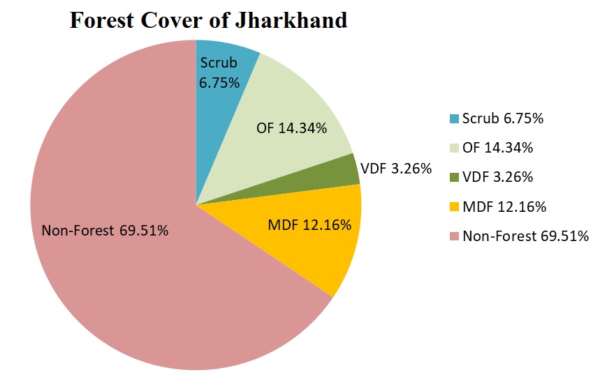
According to India’s State of Forests Report, 2021, the total Forest Cover of the state is 23,721 km2 which is nearly 29.76% of the geographical area of the state.
|
Forest Cover of Jharkhand |
||||||||
|---|---|---|---|---|---|---|---|---|
| Class | Area (km2) | % of GA | ||||||
| Very Dense Forest | 2,601.05 | 3.26 | ||||||
| Mod. Dense Forest | 9,688.91 | 12.16 | ||||||
| Open Forest | 11,431.18 | 14.34 | ||||||
| Total | 23,721.14 | 29.76 | ||||||
| Scrub | 584.20 | 0.73 | ||||||
Source : ISFR - 2021 by FSI
Of the total recorded forest area, Reserved Forest constitute 18.58%, Protected Forests 81.28% and Unclassed Forests 0.14 %
General Information
| 1 | Geographical Area | 79,716 km2. |
| 2 | Forest Area | 23721 km2. |
| 3 | Percentage forest cover of the state | 29.76% |
| 4 | Per capita Forest Area | 0.071 Ha. |
| 5 | Average density of population | 414 Persons per km2. |
| 6 | No. of Districts | 24 |
Forest Area
| Reserve Forest | 4447.21 km2. |
| Protected Forest | 17812.28 km2. |
| Undemarcated Forest | 708.67 km2. |
| Other Forest | 486.09 km2. |
| Total | 23454.25 km2. |
|
District wise Forest Cover in Jharkhand (in km2) |
||||||||
|---|---|---|---|---|---|---|---|---|
| District | Geo-graphical Area (GA) | 2021 Assessment | %of GA | Change wrt 2019 assessment | Scrub | |||
| Very Dense Forest | Mod. Dense Forest | Open Forest | Total | |||||
| Bokaro | 28,83 | 60.99 | 231.94 | 283.07 | 576.00 | 19.98 | 2.45 | 37.95 |
| Chatra | 3,718 | 244.28 | 871.73 | 666.08 | 1,782.09 | 47.93 | 4.74 | 23.57 |
| Deoghar | 2,477 | 0.00 | 14.30 | 191.50 | 205.80 | 8.31 | 2.09 | 14.04 |
| Dhanbad | 2,040 | 0.00 | 44.00 | 174.18 | 218.18 | 10.70 | 4.67 | 16.05 |
| Dumka | 3,761 | 0.00 | 259.40 | 318.23 | 577.63 | 15.36 | 0.32 | 44.55 |
| East Singhbhum | 3,562 |
54.81 |
591.69 | 434.19 | 1,080.69 | 30.34 | 1.31 | 20.91 |
| Garhwa | 4,093 | 125.14 | 415.60 | 890.98 | 1,431.72 | 34.98 | 40.13 | 44.32 |
| Giridih | 4,962 | 77.16 | 338.56 | 490.19 | 905.91 | 18.26 | 4.67 | 28.92 |
| Godda | 2,266 | 12.81 | 271.88 | 138.66 | 423.35 | 18.68 | 0.00 | 14.27 |
| Gumla | 5,360 | 304.69 | 585.81 | 552.65 | 1,443.15 | 26.92 | 0.89 | 8.25 |
| Hazaribagh | 3,555 | 230.11 | 348.54 | 784.54 | 1,363.19 | 38.35 | 10.42 | 15.99 |
| Jamtara | 1,811 | 0.00 | 20.84 | 85.18 | 106.02 | 5.85 | 5.38 | 5.32 |
| Khunti | 2,535 | 72.97 | 344.59 | 496.18 | 913.74 | 36.04 | 8.25 | 3.11 |
| Koderma | 2,540 | 80.80 | 494.43 | 447.82 | 1,023.05 | 40.28 | -0.42 | 6.37 |
| Latehar | 4,291 | 480.36 | 1,308.93 | 613.75 | 2,403.04 | 56.00 | -3.30 | 9.30 |
| Lohardaga | 1,502 | 174.03 | 218.40 | 111.99 | 504.42 | 33.58 | -0.20 | 7.66 |
| Pakur | 1,811 | 2.96 | 172.40 | 111.64 | 287.00 | 15.85 | -0.13 | 20.06 |
| Palamu | 4,393 | 62.82 | 512.73 | 640.18 | 1,215.73 | 27.67 | 14.95 | 84.23 |
| Ramgarh | 1,341 | 30.96 | 109.32 | 190.98 | 331.26 | 24.70 | 2.26 | 14.49 |
| Ranchi | 5,097 | 62.89 | 363.91 | 741.98 | 1,168.78 | 22.93 | 4.29 | 27.98 |
| Sahibganj | 2,063 | 17.74 | 258.73 | 297.48 | 573.95 | 27.82 | 1.60 | 47.53 |
| Saraikela-Kharsawan | 2,657 | 22.03 | 213.84 | 338.73 | 574.60 | 21.63 | 0.56 | 21.87 |
| Simdega | 3,774 | 21.97 | 343.54 | 877.89 | 1,243.40 | 32.95 | 2.48 | 20.28 |
| West Singhbhum | 7,224 | 461.53 | 1,353.80 | 1,553.11 | 3,368.44 | 46.63 | 2.32 | 47.18 |
| Grand Total | 79,716 | 2,601.05 | 9,688.91 | 11,431.18 | 23,721.14 | 29.76 | 109.73 | 584.20 |
.jpg)
As per the Champion & Seth classification of the Forest Types (1968), the forests in Jharkhand belong to two Forest Type Groups which are further divided into eight Forest Types.
1. Moist Peninsular Low Level Sal2. Moist Peninsular Valley Sal
3. Dry Deciduous Scrub
4. Boswellia Forest
5. Butea Forest
6. Dry Bamboo Brake
7. Dry Peninsular Sal Forest
8. Northern Dry Mixed Deciduous Forest
STATE OF FOREST REPORT 2021 (ISFR Jharkhand)
Article 48 A of the Constitution of India states:
“48A. The State shall endeavour to protect and improve the environment and to safeguard the forests and wild life of the country.”
In this spirit, the Department of Forests, Environment and Climate Change, Government of Jharkhand strives to conserve the forests, wildlife and biodiversity of Jharkhand, through the diligent implementation of the relevant Acts, rules, guidelines and schemes, thereby ensuring the environmental security of the present and future generations of the state.